

Severe thunderstorms are expected from central Texas to middle Tennessee and Kentucky this afternoon into tonight. Large hail and damaging winds are the main threats. Heavy to excessive rainfall may produce areas of flooding today and tonight from central Texas into the lower Mississippi Valley.
 |
|
Full Weather Briefing (pdf) Latest Briefing Created: Fri May 2 14:00:01 EDT 2025 |
|
Daily Situation Report (pdf) Thu Mar 27 16:00:01 EDT 2025 |
Observed Weather Briefing
 |
 Northeast Regional Radar Loop |
 痔极郤 Wakefield, VA Radar Loop |
 Dover, AFB |
 Morehead City, NC |
 Raleigh, NC |
 Sterling, VA |
 Blacksburg, VA |
 Fort Dix, NJ |
||
| Display | ||||
 Atlantic Coast Visible Loop |
 Atlantic Coast IR Loop |
 Tropical Atlantic Loop |
US Surface Analysis |
 US Surface Analysis with Radar |
 US Surface Temps | N America | World |
| Hourly Weather Roundups | Regional Temp/Precip Summaries | Miscellaneous Links |
| | | | | | Rainfall Monitor(real time) |
Weather Hazards Outlook
|
|
|
 |
|
|
|
|
 Hazard next several Days") |
|
|
|
|
 |
|
|
|
|
 |
|
|
|
|
|
|
|
|
Days 1-3 Maximum Non-TS Wind Gusts
|
|
|
|
|
Rainfall and Flood Threat Briefing
| How Much Rain Has Fallen? (Interactive) | |
 |
 |
| Precipitation Forecasts | ||||
| DAY 1 Precip Forecast | DAY 2 Precip Forecast | DAY 3 Precip Forecast | DAY 1 - 3 Total Precip Forecast | |
 |
 |
 |
|
|
| WORST CASE | |||
| 0-72 HR Worst Case PRECIP Amounts (Model Based) | |||
 |
|||
| Day 1 Excessive Rainfall Outlook | Day 2 Excessive Rainfall Outlook | Day 3 Excessive Rainfall Outlook |
 |
 |
 |
| Day 1 Precipitation | Day 2 Precipitation | Day 3 Precipitation |
 |
 |
 |
| Day 4-5 Precipitation | Day 6-7 Precipitation | 7-Day Total Precipitation |
 |
 |
 |
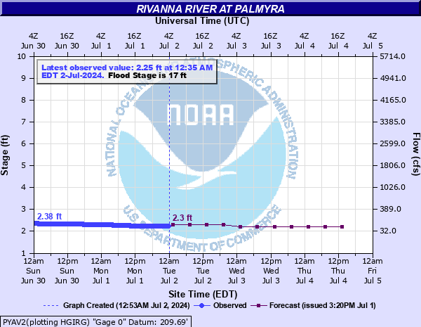
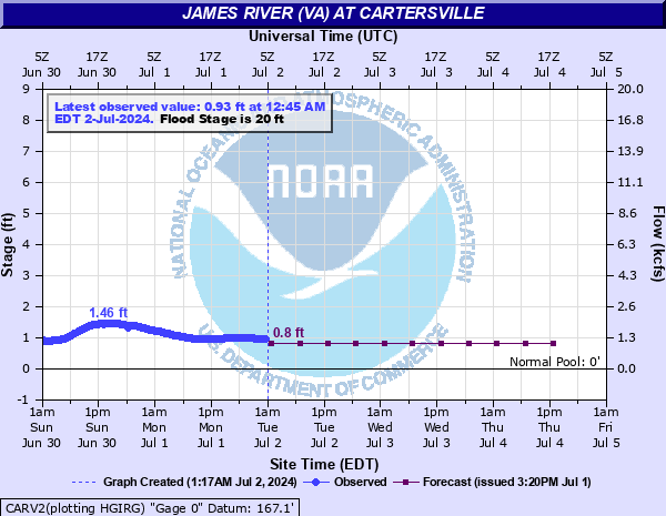
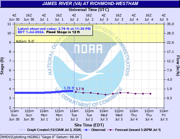
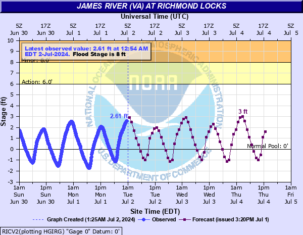
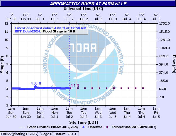
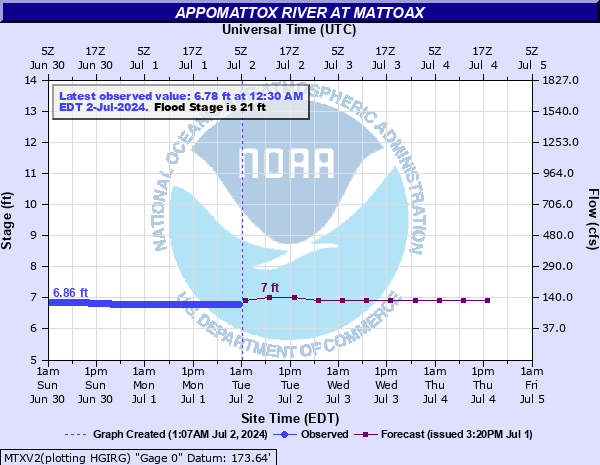
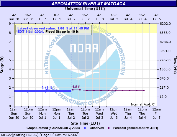
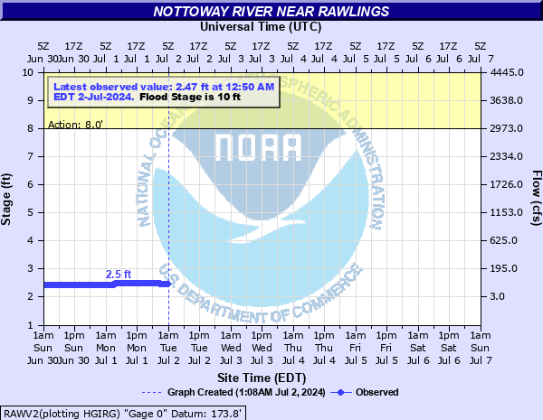
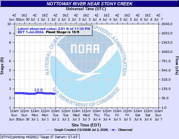
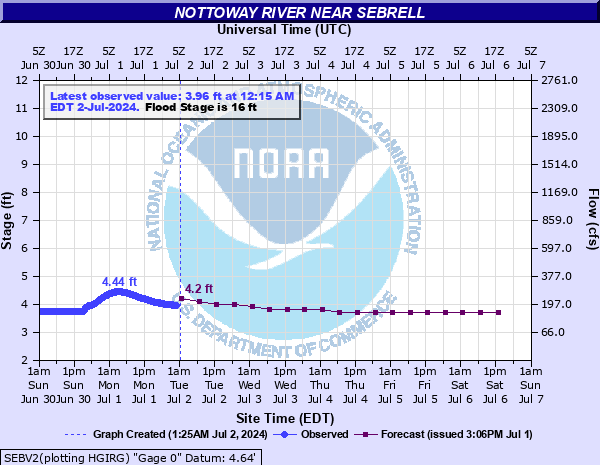
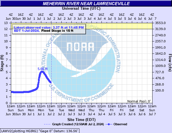
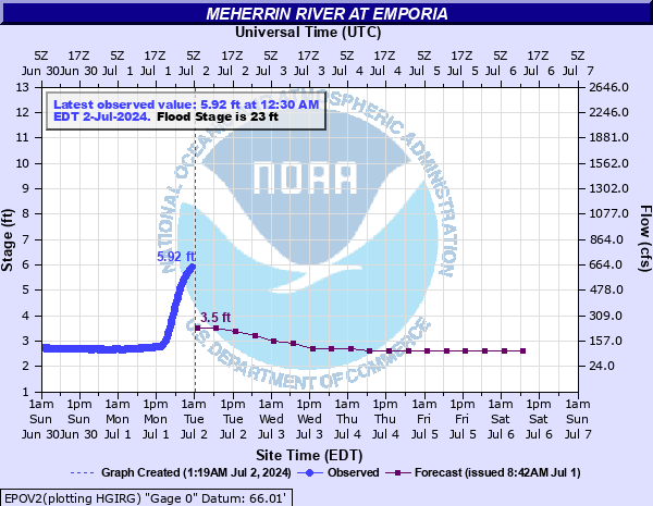
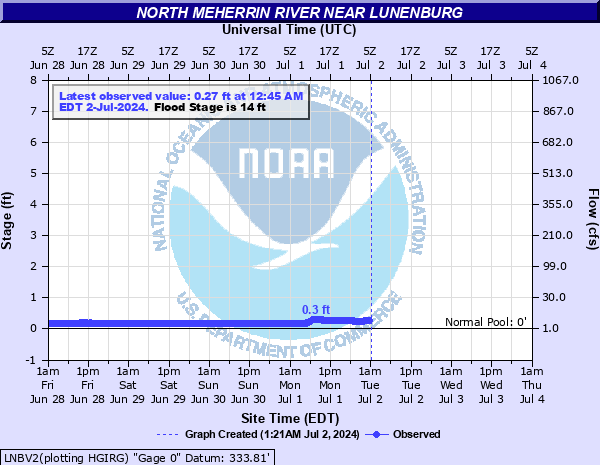
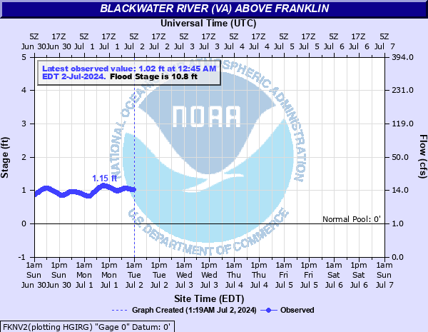
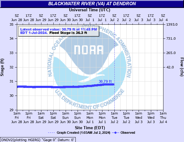
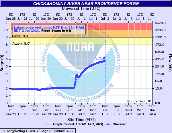
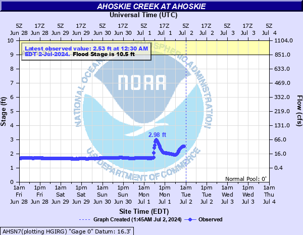
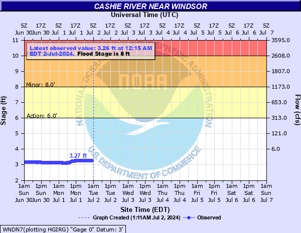
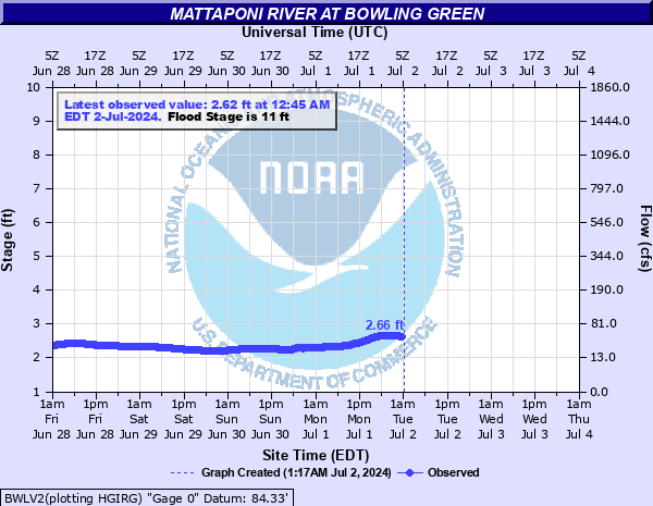
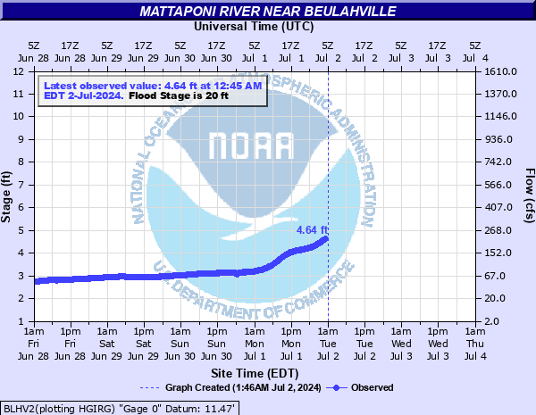
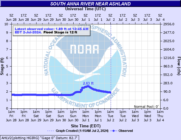
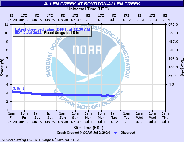
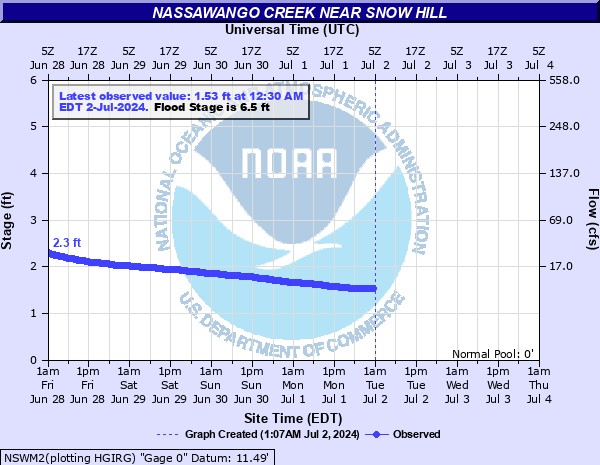
Hydrographs (showing stages and flows over time) are available through the by clicking site names.
Mouse over each site to display hydrograph.
Hydrographs (showing stages and flows over time) are available through AHPS (Advanced Hydrologic Prediction Service) by clicking site names.
|
||||||||||||||||||||||||||||||||||||||||||||||||||||||||||||||||||||||||||||||||||||||||||||||||||||||||||||||||||||||||||||||||||||||||||||||||||||||||||||||||||||||||||||||||||||||||||||||||||||||||||||||||||||||||||||||||||||||||||||||||||||||||||||||||||||||||||||||||||||||||||||||||||||||||||||||||||||||||||||||||||||||||||||||||||||||||||||||||||
Thunderstorm Threat Briefing
|
|
|
|
|||||||
|
|
|
|
|||||||
|
|
|
|
|||||
| Days 4-7 Thunderstorm Outlooks | |||
 |
 |
 |
 |
 |
 |
 |
 |
 |
Current Watches |
Storm Trend Discussions |
| Today's Storm Reports |
Yesterday's Storm Reports |
| SPC Day 1 Thunderstorm Outlook | SPC Day 1 Tornado Outlook | SPC Day 1 Severe Wind Outlook | SPC Day 1 Severe Hail Outlook |
 |
 |
 |
 |
| SPC Day 2 Thunderstorm Outlook | SPC Day 2 Tornado Outlook | SPC Day 2 Severe Wind Outlook | SPC Day 2 Severe Hail Outlook |
 |
 |
 |
 |
| SPC Day 3 Thunderstorm Outlook | SPC Day 4-8 Thunderstorm Outlook |
 |
 |
Long Range Outlook Briefing
| Days 3-7 Hazards Outlook (WPC) |
") |
| Days 8-14 Hazards Outlook (CPC) | Days 8-14 Risk of Hazardous Temperatures (CPC) | Days 8-14 Risk of Heavy Precipitation (CPC) |
") |
") |
") |
| 6-10 Day Temperature Outlook (CPC) | 6-10 Day Precipitation Outlook (CPC) |
 |
 |
| 8-14 Day Temperature Outlook (CPC) | 8-14 Day Precipitation Outlook (CPC) |
 |
 |
| **Experimental** Week 3-4 Temperature Outlook (CPC) | **Experimental** Week 3-4 Precipitation Outlook (CPC) |
 |
 |
| One Month Temperature Outlook (CPC) | One Month Precipitation Outlook (CPC) |
 |
 |
| Three Month Temperature Outlook (CPC) | Three Month Precipitation Outlook (CPC) |
 |
 |
Drought and Fire Weather Threat Briefing
| Day 1 Max Temp Forecast | Day 2 Max Temp Forecast | Day 3 Max Temp Forecast |
 |
 |
 |
| Day 1 Min RH Forecast | Day 2 Min RH Forecast | Day 3 Min RH Forecast |
 |
 |
 |
| Day 1 Max Wind Gust | Day 2 Max Wind Gust | Day 3 Max Wind Gust |
 |
 |
 |
| SPC Fire Weather Day 1 Outlook | SPC Fire Weather Day 2 Outlook | SPC Fire Weather Day 3-8 Outlook |
 |
 |
 |
 |
 |
| Seasonal Drought Outlook | NIFC Significant Fire Potential Outlook |
 |
 |
Heat Threat Briefing?
| Day 1 Excessive Heat Risk | Day 2 Excessive Heat Risk | Day 3 Excessive Heat Risk |
 |
 |
 |
 |
||
| Day 1 Max Temp | Day 2 Max Temp | Day 3 Max Temp |
|
|
|
|
| Day 1 Max Heat Index | Day 2 Max Heat Index | Day 3 Max Heat Index |
 |
 |
 |
| Day 1 Max WBGT | Day 2 Max WBGT | Day 3 Max WBGT |
 |
 |
|
| Day 1 Min Temp Forecast | Day 2 Min Temp Forecast | Day 3 Min Temp Forecast |
 |
 |
 |
| 3 Hourly Heat Index |
 |
 |
 |
 |
 |
 |
Wind Threat Briefing
| Day 1 Wind Risk | Day 2 Wind Risk | Day 3 Wind Risk |
 |
 |
 |
 |
||
| Day 1 Max Sustained Wind | Day 2 Max Sustained Wind | Day 3 Max Sustained Wind |
 |
 |
 |
| Day 1 Max Wind Gust | Day 2 Max Wind Gust | Day 3 Max Wind Gust |
|
|
|
| 0-72 HR Max SUSTAINED Wind | 0-72 HR Max Wind GUST | 0-72 Hour HR Worst Cast Peak Wind Gust |
 |
 |
 |
| 3 Hourly Wind Speed & Direction Forecasts |
 |
 |
 |
 |
 |
 |
| 3 Hourly Wind Gusts |
 |
 |
 |
 |
 |
 |
|
Thunderstorm, Tornado and Lightning Safety
|
Winter Weather Safety
|
NOAA Weather Radio
|
||||
|
Hurricane Safety and Preparedness
|
Flooding Safety
|
|||||
|
|
|
|||||
|
Heat Safety
|
Miscellaneous Safety and Preparedness
|
|||||
|
|
|
|||||
|
Additional 痔极郤 Preparedness Web Pages
|
||||||
|
More Useful Resources
|
||||||
|
|
||||||
Marine Product/Threat Briefing?
| Marine Observations as of 12:00 PM EDT Sat May 03 2025 | |||||||
| Location | UTC TIME | Air Temp (°F) |
Water Temp (°F) |
Wind (DIR/SP/Gust) |
Pres (mb) |
Wave&Swell (HT/PER) |
|
| 1530 | 76 | 68 | 180/ 2/ 6 | N/A | |||
| 1530 | 72 | 67 | 220/ 8/ 11 | 1012.5 | |||
| 1530 | 74 | 240/ 10/ 12 | 1012.2 | ||||
| 1530 | 77 | 69 | 210/ 10/ 14 | 1013.8 | |||
| 1600 | 75 | 200/ 11/ 12 | 1013.6 | ||||
| 1548 | 71 | 65 | 210/ 8/ 10 | N/A | 1 | ||
| 1530 | 75 | 190/ 14/ 18 | 1013.5 | ||||
| N/A | N/A | N/A | N/A | N/A | N/A | N/A | |
| 1530 | 72 | 72 | 200/ 16/ 17 | 1014.0 | |||
| 1548 | 71 | 66 | 210/ 12/ 14 | N/A | 1 | ||
| N/A | N/A | N/A | N/A | N/A | N/A | N/A | |
| 1530 | 77 | 71 | 230/ 13/ 18 | 1013.6 | |||
| 1530 | 76 | 71 | 230/ 11/ 14 | 1012.3 | |||
| 1530 | 180/ 14/ 15 | 1015.6 | |||||
| 1548 | 73 | 220/ 14/ 21 | N/A | 1 | |||
| 1530 | 77 | 68 | 210/ 17/ 25 | 1014.4 | |||
| 1548 | 72 | 67 | 220/ 14/ 17 | N/A | 2 | ||
| N/A | N/A | N/A | N/A | N/A | N/A | N/A | |
| 1530 | 74 | 240/ 16/ 18 | 1015.2 | ||||
| 1530 | 75 | 240/ 12/ 16 | 1015.3 | ||||
| 1530 | 78 | 72 | 210/ 10/ 13 | 1015.2 | |||
| 1530 | 76 | 69 | 1014.7 | ||||
| 1530 | 71 | 66 | 220/ 9/ 10 | 1015.5 | |||
| 1530 | 74 | 220/ 9/ 11 | 1014.6 | ||||
| 1530 | 79 | 210/ 8/ 20 | 1015.5 | ||||
| 1530 | 81 | 58 | 170/ 12/ 17 | 1013.0 | |||
| 1550 | 62 | 56 | 200/ 17/ 21 | 1013.9 | 5 | ||
| 1530 | 73 | 230/ 16/ 18 | 1013.1 | ||||
| 1530 | 62 | 66 | 210/ 16/ 18 | 1014.3 | |||
| 1530 | 78 | 73 | 240/ 11/ 19 | 1014.9 | |||
| N/A | N/A | N/A | N/A | N/A | N/A | N/A | |
| 1556 | 65 | N/A | 3 | ||||
| N/A | N/A | N/A | N/A | N/A | N/A | N/A | |
| N/A | N/A | N/A | N/A | N/A | N/A | N/A | |
| 1550 | 64 | 180/ 10/ 12 | 1017.2 | 4 | |||
| N/A | N/A | N/A | N/A | N/A | N/A | N/A | |
| N/A | N/A | N/A | N/A | N/A | N/A | N/A | |
| 1530 | 76 | 58 | 210/ 17/ 22 | 1016.6 | |||
| 1530 | 73 | 74 | 230/ 20/ 23 | 1017.9 | |||
| 1550 | 74 | 200/ 14/ 17 | 1017.8 | 4 | |||
| 1550 | 76 | 190/ 14/ 19 | 1017.8 | ||||
DAILY MARINE THREAT
| TODAY | TOMORROW | DAY 3 | DAY 4 | DAY 5 |
 |
 |
 |
 |
 |
 |
||||
MARINE WAVE/WIND FORECASTS
| Max Wave Height Day 1 | Max Wave Height Day 2 | Max Wave Height Day 3 | Max Wave Height 0-72 HR |
 |
 |
 |
 |
| Max Wind Gust Day 1 | Max Wind Gust Day 2 | Max Wind Gust Day 3 | Max Wind Gust 0-72 HR |
 |
 |
 |
 |
HOURLY WEATHER GRAPHS
|
|
| Complete Wind Gust Likelihood and Probabilities Page |
LIKELIHOOD OF WIND GUSTS
| 25 KT LIKELYHOOD | 34 KT LIKELYHOOD | 43 KT LIKELYHOOD | 48 KT LIKELYHOOD | FORECAST WIND GUST | HIGH END WIND GUST |
 |
 |
 |
 |
 |
 |
| RIP CURRENT FORECAST (MAY-SEPT) |
 |


 Coastal Flood
 Heat
Heat